The maps below show the town of Riverport in 1900 and 2000. Summaries the information by selecting and reporting the main features, and make comparisons where relevant.
The maps below show the town of Riverport in 1900 and 2000. Summaries the information by selecting and reporting the main features, and make comparisons where relevant.
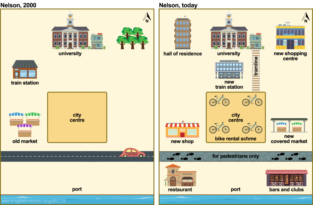
The maps illustrate how the town of Riverport changed between 1900 and 2000.
Overall, riverport underwent major development over the century, with new facilities such as a university, shopping areas, and entertainment venues replacing older features like the market and port .the town became more modern and organized by 2000.
In 1900 Riverport was a much simpler town. The old market was located to the west of the city centre. while train station was situated in the northwest. the port lay in south, beside the river, and the main road passed directly through it. There were few buildings apart from these key areas.
By 2000, the town had been completely modernized. A university had been established in the north, with a hall of residence nearby. To the east, a new shopping centre replaced open space, and the old market and new shops. A bike rental sheme around the city centere, and the southeran road became for pedestirans
No paragraphing between intro and overview
centre. while> sentence structure
replaced open spac > missing word
A bike rental sheme around the city centere, and the southeran road became for> SM
Band score: 6.0
The map illustrate the difference in the local city between 1900 and 2000.
Overview, the Nelson had dramatic changes after the many years. In the meantime, new train station, hall of residence, new shopping center, restaurant.
In the past, city center was midile of the Nelson city. There was a veehical
road for car. North sight was the university and many trees. Train station was sought sight of the Nelson city.
Now the city center had bike rental schme. new hhall of residence was North south of west sight. New shopping center in north side. The road change in for
No paragraphing at all
. In the meantime, new train station, hall of residence, new shopping center, restaurant.> sentence making
There was a veehical
road for car. North sight was the university and many trees.> Unclear data and SM
sought > SP
. new hhall of residence was North south of west sight. > Cap, sp
New shopping center in north side. The road change in for> Sm and incomplete
The maps illustrates the development of the town of riverport in before and after.
overall, the town had witnessed some massive infrustructural development over the years. However, the hall of residence, shopping centre, restaurant, bars and clubs, covered market are newly constructed in the town. although, the train station and old market had reparing a new train station and new shop.
No paragraphing
overall> Cap
although, the train station and old market had reparing a new train station and new shop.> Cap and sentence making
The two maps demonstrate the differences made in the town of Riverport between 2000 and the present state.
Overall, Riverport town witnessed a huge changes over period. After renovation there were some new infrastructure made including hall of residence, new shopping centre, train station, market, restaurant, bars and clubs.
In 2000, there was a university in northern part of Nelson, some trees were planted next to the university. Moreover, some old markets was situated close to the city centre, which was infront of the train station. After wards, a highway belongs in the south, which was close to the port.
In the present, some changes is made with new infrastructure. A hall of residence constructed next to the university located in the northwest part. After that, the train station expanded and relocated to infront of university. In the area of city center bike rental services is started and the road replaced by footpath, which is only used by pedestrians.
he two maps demonstrate the differences made in the town of Riverport between 2000 and the present state.> sentence making
over period> Article
After renovation there were some new infrastructure made including hall of residence> SM
markets was situated > Tense
After wards,> Gap
arted and the road replaced by footpath > Sentence structure
The maps illustrate some changes that were made to Riverport between 1900 and 2000.
It is clear that a number of major changes these include a hall of residence , a new shopping center, a new train station and so on.
Looking at the charts in more detail, in the past, northwest corner constructed a big hall of residence in the nelson city today, while in the northeast corner included a new shopping center. Moreover, in the past the port side was empty, but the present day the southwest corner built a restaurant and the southeast corner included a bars and clubs.
In addition, Nelson city had a main road, included cars, whereas today this road make for just pedestrians only. Furthermore, in city meddle a empty space, now in this space made a bike rental schme. On the other hand, in the past left side had a old market, but now this made a new shop, which acroce the bike rental schme, in pas this space had empty, now made a new coverd
number of major changes these include a hall of residence , a new shopping center, a new train station and so on.> Sm
, while in the northeast corner included a new shopping center> SM
the present day > in the present day
included > WF
, in city meddle a empty space> sp and unclear
but now this made a new shop,> Sm
acroce , schme ,pas> SP
in pas this space had empty,> sm
The two maps illustrates the town of Riverport in 1999 and 2000.
Overall, the town has dramatically development and modernization over the years. Several new shop, new covered market, restaurant, new shopping center including.
In 2000, the town had University, train station, Old market , and north east corner trees, city center had the empty, and it down had a road, south side had a pot.
At present, North west side has include hall of residence, in city center including new bike rental scheme. Trees replaced new shopping center. Moreover, include new train station and it beside tramline , Old market demolished and replace new shop. Including restaurant and bars and clubs under pot. In contrast, road demolished and University remains day, How ever new covered market including southest corner . In additon pot sid
, the town has dramatically development and modernization over the years.> SM
Several new shop, new covered market, restaurant, new shopping center including.> SM
In 2000, the town had University, train station, Old market , and north east corner trees, city center had the empty, and it down had a road, south side had a pot.> SM
, North west side has include hall of residence> SM
The pictures portrays a town called nelson, which look completely different from the year 2000.
Overall, the town called Nelson has seen dramatic changes over a decade, by which the town has been urbanized for the residents. However, new hall of residents, new shopping center, new shop, restaurant are built in the meantime.
In 2000, there were trees in the northeastern part of the town, in the left side of trees there was a university. There was port in the south part of the won and in front of the road there was a road. In the east part of the town, train station and old market is located in a small distance.
At present, in the city center bike rental schme is introduced, and old market is replaced by new shop, which are located left side of bike rental schme , whereas old market is modified by new covered market. There is restaurant, and bars and clubs built in the both side of the port.
portrays> WF
which look completely different from the year 2000.> SM
No paragraphing between overview and BP1
won > SP
train station and old market is located in a small distance.> Sentence structure
which are located left side of> tense
The two maps illustrate a bout the development of Riverport over the hundreds years period.
Overall, the two maps reveal a complete transformation between 2000 and 2025. while, nelson riverport has significant changed including new development of half of residence, new shops, new shopping center, new covered market, restaurant, and bars and clubs.
looking to the northside of nelson riverport to northeast corner, tress are chopped down to make way a new shopping center. Notably that a new development of half of residence has made in todays nelson riverport to the northwest of corner, and a new train station has placed in the middle between university and city center in 2025, whereas a tramline has set up besides station.
looking to the southwest corner of riverport, the old market has demolished for making a new shop opposite site of city center. A new development of covered market has constructed to the southeast corner of nelson riverport. It is noticeably, for pedestrian a restaurant has put on to the downside side of port in left, and a bar and clubs has launched to the right side of the port.
a bout > splitting
hundreds> Wrong info
while, nelson riverport has significant changed including new development of half of residence, new shops, new shopping center, new covered market, restaurant, and bars and clubs.> Sentence structure
looking > Cap
has placed in the middle between > Sm
2025 > Wrong info
old market has demolished for making a new shop opposite site of city center> Sm
noticeably> word form
and a bar and clubs has launched to the right side of the port.> SM
Band score : 6.0
The map illustrates the city of Riverport from 1900 and 2000.
Overall, the port passes through various changes in the meantime. New market, shopping center, bike rental schme, shops, bars and clubs, restaurant, train station, hall of residence are constructed in the port.
In 2000, the city center was vacant. University was located at the top of the map and some trees were situates near the university. A train station was at the west side of the map and an old market was located at the left side of city center.
Currently, the university is still at its previous place. Tress were chopped down and the city center was replaced by bike rental schme. Old market was converted to new shop and a new covered market was added. They rebuilt the train station to a new place. In the northwest corner a building called hall of residence was built, on the other side a new shopping center were constructed. A restaurant and a bar and club were expanded to the side of the port. lastly the road was converted to pedestrians.
No paragraphing at all
*** Copied
The pictures illustrates the town of riverport area, in the year of 1990 and 2000.
Overall, the city name is Nelson, which is located in riverport. In the year 2000, there was a old market in the roadside and behind the market train station, old market left side city center located. But now a days, the city is fully changed.
However, now a days, the old city converter new shop, train station also change, and the city centre right side open a new covered market. in 2000, the north side there was a tree garden, presently there is a new shopping centre. In the river port area, recently open a new restruant and a bars and clubs.
At present, in the town the city center schme bike rental. behind the city center new railway station presently.
No paragraphing at all
year of > Preposition
, old market left side city center located> SS
, now a days, > Gap and Punctuation
Overall, the city name is Nelson, which is located in riverport. In the year 2000, there was a old market in the roadside and behind the market train station, old market left side city center located. But now a days, the city is fully changed.> Over info in overview
the old city converter new shop, train station also change, and the city centre right side open a new covered market. > SM
At present, in the town the city center schme bike rental. behind the city center new railway station presently.> SM
The two maps illustrate how the town of Nelson has developed from 2000 to the present day.
Overall, the town has undergone significant modernization, with the addition of new facilities such as shopping centres, residential buildings, and leisure areas. While some original features remain unchanged, others have been replaced or upgraded to serve the changing needs of the town.
In 2000, Nelson had a train station to the west of the city centre and an old market located just south of it. The port was connected by a road used by vehicles, and next to the port there was little development. The university was located to the north of the city centre, surrounded by some greenery.
By today, the town has seen numerous transformations. The old train station has been replaced by a new, modern station, and a bike rental scheme has been introduced in the city centre, promoting eco-friendly transportation. The old market was removed, making way for a covered market to the southeast and a new shop to the southwest of the city centre.
The two maps illustrate the major changes that have taken place in the town of Nelson between the year 2000 and the present.
Overall, Nelson has undergone significant modernization and development,with the addition of new facilities such as a hall of residence,tramline,and bike rental scheme, as well as the transformation of the port area into a recreational zone.The town has clearly become more pedestrian-friendly and commercially active.
In 2000, the main features of Nelson included a university in the north, a train station to the west, an old market to the southwest, and a port in the south. The city centre occupied the the main central portion of the map,surrounded by open spaces and a few trees.
At present,several notable change have occurred.A hall of residence has been built to the east.The former train station has been replaced by a new expanded station,connected to the university area by a tramline.The old market replaced by a new covered market, whilst a new shop are there near city centre and it now redesigned a bike rental scheme.The road near port converted into a pedestrian zone.Additionally, the port upgraded with a restaurant and bar and club.
The maps below demonstrate a city of Riverport in the year 1900 and 2000.
Overall, the city had gone through dramatic changes in the meantime. New buildings, footpath, markets, train station, shops were built.
In 2000, there was a city center and the west sight of city center there were an old market. On the other side of the old market there was a train station. A University was situated at the top of the map and there were some wooded area beside the university. there was also a port which has at the bottom of the map. A road passes through beside the port.
Currently, the city has changed a lot. At the city center there is a bike rental schme, old markets and wooded was replaced by new shops and new shopping center. Train station was removed from its previous place, they rebuilt it next to the city center. A train line pass by the train station. University is still at his old place. In the northwest corner a new building called hall of residence was built by them, and a new covered market take place in the east side of the city center. A restaurant and a bar and club were built beside port.